
The Science Behind Cloud Formation and Types

Observing clouds in the sky reveals a fascinating interplay of temperature, humidity, and air pressure. These elements combine to form various cloud types, each with unique characteristics. From high-altitude, wispy cirrus clouds to low-lying, blanket-like stratus clouds, the diversity is striking. But what causes water vapor to condense into droplets or ice crystals, and how do these particles influence weather patterns? Understanding the science behind cloud formation answers these questions and unveils the intricate processes shaping our atmosphere.
Water Vapor and Evaporation
Water vapor enters the atmosphere primarily through the evaporation of water from oceans, lakes, and rivers. When the sun heats these water bodies, liquid water transforms into water vapor, which then mixes with the air. This process, known as evaporation, is essential for increasing the water vapor content in the atmosphere.
As air rises, it expands and cools, allowing the water vapor to begin condensing. However, water vapor requires tiny particles like dust or pollen, known as condensation nuclei, to condense upon. These particles provide the necessary surfaces for water vapor to transform back into liquid form.
Without evaporation, there wouldn't be sufficient water vapor in the air to initiate cloud formation. Similarly, without condensation nuclei, water vapor would struggle to form clouds. Thus, evaporation and the presence of condensation nuclei are crucial for cloud formation. Understanding these processes highlights the intricate and finely tuned nature of our atmosphere in terms of weather and cloud formation.
Condensation and Cloud Formation
Condensation occurs when water vapor in the air cools and adheres to tiny particles like dust or pollen, forming liquid droplets. This process is essential for cloud development. As water vapor condenses, it turns into visible cloud droplets, which are observable in the sky. These droplets gather around condensation nuclei, which include particles like dust, salt, or pollen.
Condensation is critical because it allows water vapor to transform into a form conducive to cloud creation. Without these small particles, known as condensation nuclei, water vapor would lack a surface to attach to, making cloud formation nearly impossible. For a more precise understanding, consult the table below that outlines the main aspects of this process:
| Process | Key Component | Result |
|---|---|---|
| Condensation | Water vapor | Liquid droplets |
| Condensation | Condensation nuclei | Formation of droplets |
| Cloud Formation | Water vapor + nuclei | Visible clouds |
| Transformation | Vapor to liquid | Cloud droplets |
Understanding condensation and cloud formation is crucial for grasping the dynamics of the atmosphere and weather patterns. By learning how water vapor condenses into cloud droplets around condensation nuclei, you can better appreciate the complex processes that create the clouds we see daily.
Role of Condensation Nuclei

Tiny particles like dust and pollen, known as condensation nuclei, play a crucial role in cloud formation. They attract water vapor, facilitating the growth of droplets that eventually form clouds. Without these particles, the development of clouds would be significantly hindered.
Particles Initiate Cloud Formation
Tiny particles like dust, pollen, and salt are essential for initiating cloud formation by acting as surfaces for water vapor to condense on. These particles, known as condensation nuclei, provide the necessary substrates for water vapor to transition from a gas to liquid water droplets, forming clouds.
The presence of condensation nuclei is crucial for cloud formation. As water vapor condenses around these microscopic particles, it forms water droplets that cluster together to create clouds.
The size and composition of these nuclei influence the properties of the resulting cloud droplets, which subsequently affect weather patterns. For instance, larger condensation nuclei can lead to larger droplets and potentially heavier precipitation.
Dust and Pollen Role
Dust and pollen serve as critical condensation nuclei in the atmosphere, providing surfaces for water vapor to transform into cloud droplets. These tiny particles give water vapor something to cling to, initiating cloud formation. Without these nuclei, water vapor would struggle to condense into visible droplets, making cloud formation much more challenging.
Here's a breakdown of their role in cloud formation:
| Particle Type | Function | Importance in Cloud Formation |
|---|---|---|
| Dust | Surface for condensation | Essential for initial droplet formation |
| Pollen | Surface for condensation | Important for visible cloud development |
| Water Vapor | Condenses on nuclei | Forms cloud droplets |
| Condensation Nuclei | Facilitate condensation | Necessary for cloud formation |
| Clouds | Result of condensation | Visible masses in the atmosphere |
Each element in this process is interdependent. Dust and pollen provide the necessary surfaces for water vapor to condense, making them indispensable in cloud formation. Understanding the role of these condensation nuclei offers insight into the intricate processes that create the clouds in the sky.
Nuclei Influence Droplet Growth
Condensation nuclei play a critical role in cloud formation by providing surfaces for water vapor to condense onto. These tiny particles, which can include dust, salt, or pollen, are essential for the formation of visible clouds. Without them, water vapor would remain in the atmosphere as an invisible gas, preventing cloud formation.
The process begins when water vapor condenses onto these particles, forming cloud droplets. These droplets then aggregate to create clouds. This mechanism not only initiates cloud formation but also affects cloud properties such as droplet size and cloud lifespan. For instance, sulfur dioxide particles from volcanic eruptions can serve as condensation nuclei, significantly impacting cloud formation.
Key reasons why condensation nuclei are vital include:
- Surface for Condensation: They provide a necessary surface for water vapor to transition from gas to liquid.
- Droplet Formation: They initiate the formation of cloud droplets.
- Cloud Properties: They influence the size of the droplets and the longevity of the clouds.
- Environmental Impact: Different types and concentrations of particles can alter cloud formation in various ways.
Understanding the role of condensation nuclei is crucial for comprehending the complex dynamics of cloud formation and the multiple factors that influence weather patterns.
Cloud Formation Processes
Cloud formation begins when water vapor condenses onto particles like dust, pollen, and salt crystals, forming tiny droplets that combine to create clouds. Understanding this process requires recognizing that when moist air rises, it cools and expands due to lower atmospheric pressure. As the air cools to its dew point, water vapor condenses onto condensation nuclei—essential particles without which liquid droplets wouldn't form as easily.
As moist air ascends, it carries water vapor with it, expanding and cooling in response to lower pressure. When the temperature falls to the dew point, water vapor condenses around condensation nuclei, forming liquid droplets. This mechanism is crucial for cloud formation and is driven by the hydrological cycle and solar energy.
The interaction between rising air, cooling temperatures, and condensation nuclei results in cloud creation. Understanding this process highlights how energy transfer and air mass interactions influence cloud dynamics. This foundational knowledge is key to comprehending broader atmospheric phenomena and the weather patterns that affect our daily lives.
Weather Fronts and Clouds
Understanding cloud formation processes sets the stage for exploring how weather fronts influence cloud types and weather patterns. Weather fronts occur when two air masses with different temperatures and humidity levels collide, leading to the formation of various cloud types and significantly impacting local weather conditions.
Key Points on Weather Fronts and Cloud Types
- Warm Fronts: Produce nimbostratus and altostratus clouds. Warm air rises over colder air, causing the moisture in the warm air mass to condense into these cloud types.
- Cold Fronts: Typically bring cumulus and cumulonimbus clouds, often leading to thunderstorms. As the cold air displaces the warm air, the rising warm air cools rapidly, resulting in cloud formation and intense weather.
- Atmospheric Conditions: Impact cloud formations at both warm and cold fronts, sometimes producing stratocumulus, stratus, or nimbostratus clouds, depending on the stability and moisture content of the air masses involved.
- Importance: Weather fronts play a crucial role in determining cloud types and regional weather patterns, making them essential for accurate weather prediction.
Understanding these dynamics helps you predict the kind of weather associated with specific fronts, enhancing the accuracy and reliability of weather forecasting.
Factors Influencing Cloud Types
Temperature, elevation, and humidity in the atmosphere are crucial in determining the types of clouds that form. When air masses with different temperatures collide, the warmer air typically rises above the cooler air. As this warm air ascends, it cools and, if sufficiently moist, condenses to form clouds. The temperature and humidity at various elevations dictate whether clouds will be fluffy cumulus or thin, wispy cirrus.
Elevation is vital because clouds develop at different atmospheric levels. Low-altitude clouds, such as stratus, form closer to the Earth's surface, whereas high-altitude clouds like cirrus form higher up where the air is colder. The temperature at these elevations affects the type and characteristics of the clouds.
Humidity is another key factor. Saturated air is more likely to produce dense, thick clouds, while drier air results in more dispersed and less defined formations. Understanding these variables—temperature, elevation, and humidity—enables meteorologists to predict weather patterns and classify clouds based on their formation and location in the atmosphere.
Different Types of Clouds

When you look up at the sky, you'll notice various types of clouds forming at different altitudes. High-altitude clouds like cirrus are thin and wispy, whereas low-altitude clouds such as cumulus are rounded and puffy. For clouds with significant vertical development, cumulonimbus clouds are the most dramatic, often associated with thunderstorms and severe weather.
High Altitude Clouds
High altitude clouds, including cirrus, cirrostratus, and cirrocumulus, form above 20,000 feet and are composed of ice crystals due to the cold temperatures at such elevations. These clouds are fascinating, each with distinct characteristics. Cirrus clouds are thin and wispy, often resembling delicate strokes across the sky. They usually indicate an approaching warm front. Cirrostratus clouds cover the sky in a thin, veil-like layer, often creating halos around the sun or moon due to the refraction of light by the ice crystals within them. Cirrocumulus clouds appear as small, white patches that resemble fish scales, a pattern often referred to as a 'mackerel sky.'
Here are some key points about high altitude clouds:
- Cirrus Clouds: Thin, wispy, and often indicate a change in the weather.
- Cirrostratus Clouds: Cover the sky as a thin veil and can create halos.
- Cirrocumulus Clouds: Small, white patches resembling fish scales.
- Ice Crystals: All high altitude clouds are composed of ice due to cold temperatures.
Understanding these clouds helps in predicting weather changes and appreciating the beauty of our atmosphere.
Low Altitude Clouds
Low altitude clouds, forming below 2,000 meters in the troposphere, include several types like cumulus, stratus, and stratocumulus, each with distinct characteristics. Cumulus clouds are rounded, puffy formations often scattered across the sky, typically associated with fair weather. However, their vertical growth can indicate upcoming changes in weather patterns.
Stratus clouds are flat and layered, resembling a gray blanket covering the sky, often bringing overcast conditions and light rain or drizzle. These clouds create a uniform, dull appearance, blocking out the sun and giving the day a gloomy feel.
Stratocumulus clouds are a hybrid of the two, appearing in patches or layers with a bumpy texture. While they usually don't bring heavy precipitation, they can signal an approaching weather front or system.
Understanding these low altitude clouds helps predict weather patterns and prepare for potential changes in atmospheric conditions. Observing the sky can provide valuable insights into local weather dynamics.
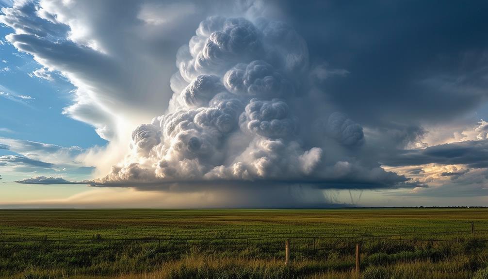
Vertical Development Clouds
Vertical development clouds, such as cumulonimbus, are towering formations that often bring severe weather. These clouds can reach altitudes of up to 20,000 meters and are easily recognized by their anvil-shaped tops, which spread out due to strong upper-atmosphere winds.
Cumulonimbus clouds are associated with a variety of severe weather conditions, including:
- Thunderstorms: These clouds are responsible for thunder and lightning.
- Heavy precipitation: They can produce intense rainfall, sometimes causing flash floods.
- Lightning: Frequent and intense lightning strikes are common.
- Hail: Severe cases may involve hail formation.
These clouds play a significant role in the water cycle and the development of severe weather systems, influencing weather patterns and contributing to heavy precipitation. If you see these massive clouds with their anvil-shaped tops, be prepared for potential thunderstorms and severe weather.
High-Altitude Cloud Formation
When you look up and see delicate, wispy clouds floating high above 20,000 feet, you're witnessing the formation of high-altitude clouds. These clouds, primarily composed of ice crystals, form in the cold, upper reaches of the atmosphere. Among the most common types are Cirrus clouds, which appear as thin, feather-like streaks due to the ice crystals reflecting sunlight.
Cirrostratus clouds, another type of high-altitude cloud, spread across the sky like a thin, milky veil. These clouds often cover large areas and can give the sky a uniform, hazy appearance. They're also known for creating halos around the sun or moon, a phenomenon caused by the refraction of light through the ice crystals.
Lastly, Cirrocumulus clouds appear as small, white patches or rows, often resembling fish scales. While not as common, these clouds are equally captivating. Each type offers a glimpse into the complex processes occurring at high altitudes. Understanding these clouds helps you appreciate the intricate dynamics of our atmosphere and the diverse forms water vapor can take when it freezes into ice crystals.
Cloud Detection Technologies

Detecting clouds and their properties is essential for both weather forecasting and aviation safety. Understanding the various detection technologies in place to monitor cloud conditions, particularly those containing ice crystals that pose a threat to aircraft, is crucial.
Weather radars are a primary technology utilized in this field. They differentiate between types of precipitation, including ice crystals, through the use of differential reflectivity. Ice crystals have unique horizontal dimensions, making them easier to identify.
In the aerospace industry, radar technology is being developed to detect ice crystal environments, crucial for preventing ice accumulation on aircraft surfaces. This is important because ice crystals can melt on warm aircraft surfaces and subsequently refreeze, causing potential damage.
Key points about cloud detection technologies include:
- Weather Radars: Use differential reflectivity to distinguish between different types of precipitation, including ice crystals.
- Ice Crystal Detection: Advanced radar technologies are designed to detect ice crystals, preventing ice accumulation on aircraft surfaces.
- Safe Flight Operations: Identifying ice crystal environments is vital for maintaining aircraft safety and preventing potential damage.
- Technology Development: Continuous advancements are being made in radar technology to enhance cloud and ice crystal detection capabilities.
These technologies contribute to safer flight operations and improved weather forecasting by accurately monitoring and identifying hazardous cloud conditions.
Conclusion
You've now delved into the fascinating science behind cloud formation and their various types. It all begins with water vapor and condensation, influenced by temperature and humidity. Different atmospheric conditions give rise to diverse cloud formations, from wispy cirrus to towering cumulonimbus. Understanding these processes not only enhances your appreciation for the sky but also aids in weather prediction. So next time you look up, you'll see clouds in a whole new light!